
Waterfront Real Estate Photography in the DC Metro & Chesapeake Area: A 2026 Guide
Few listings sell themselves the way a waterfront home can — but only if the marketing actually puts the water front and center. A buyer looking at a home on the Magothy, the Severn, or a quiet creek off the Chesapeake is buying a view and a lifestyle, not just square footage. When the photography treats a waterfront property like any other listing — interiors first, a token exterior, no real sense of the shoreline — it leaves the single most valuable feature on the table.
And that value is real. Zillow research has put the national sale-price premium for waterfront homes at roughly 36 percent over comparable inland homes, though it varies widely by market and by the type of water frontage. When a property carries that kind of premium, the listing photos have a bigger job to do: they have to justify it.
Here is how waterfront listings should be photographed across the DC metro and Chesapeake region — the shots they need, how local airspace rules shape what's possible, and how to prep a waterfront home so it shows at its best.
Why Waterfront Listings Demand More From Photography
On a standard listing, the house is the product. On a waterfront listing, the water is half the product — sometimes more. Buyers scrolling Bright MLS want to know how close the water is, what the view looks like from the back of the house, whether there's a usable dock, and how private the lot feels. If the photos don't answer those questions, the listing reads like an ordinary house at a waterfront price, and buyers keep scrolling.
The job is to show the relationship between the home and the water as clearly as possible: how close, how private, how usable. That takes a wider mix of shots than an interior-only gallery — and it almost always takes an aerial.
The Shots a Waterfront Listing Actually Needs
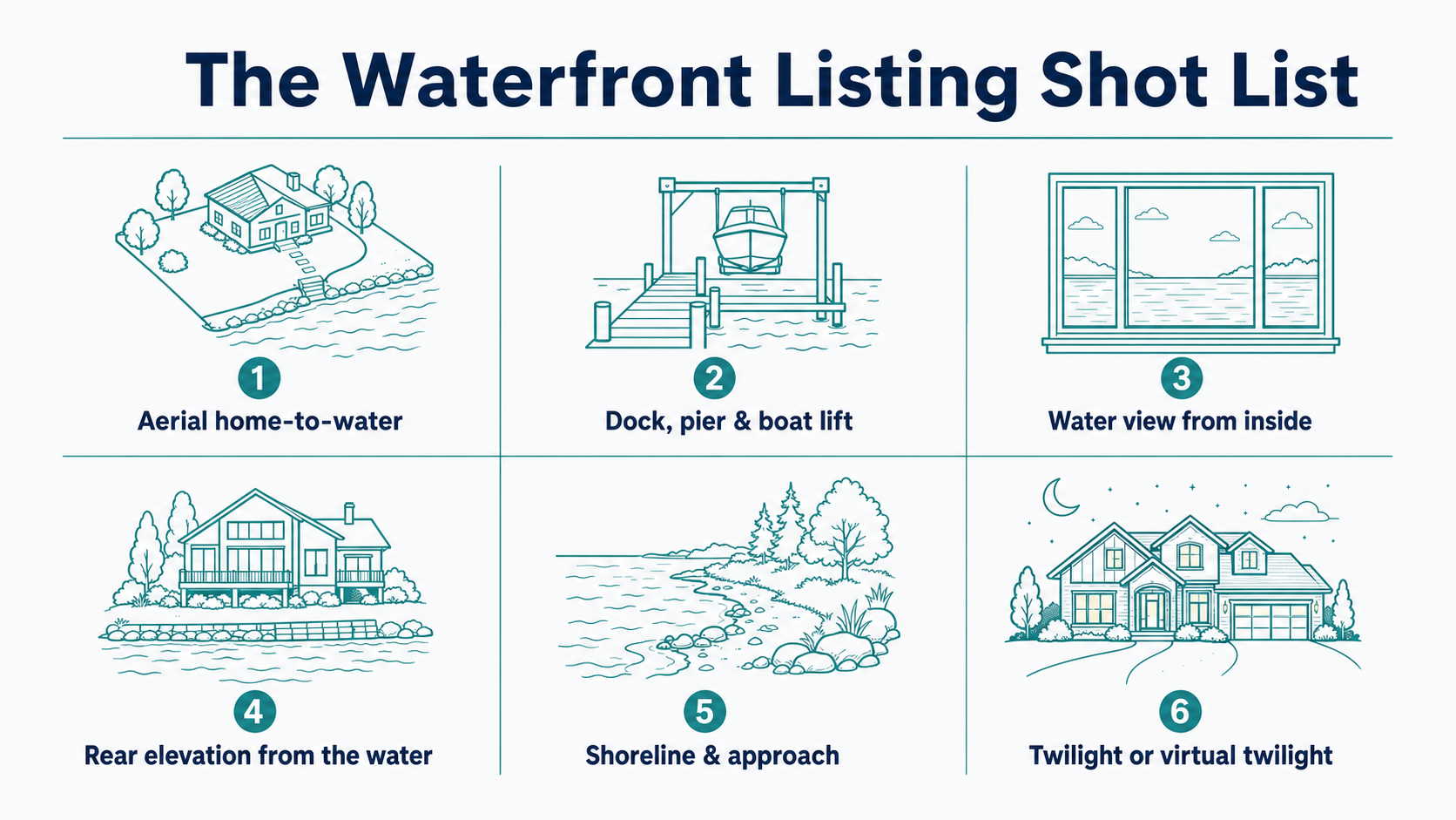
A complete waterfront gallery goes well beyond the usual interior-and-front-elevation set. The shots that actually move waterfront buyers are:
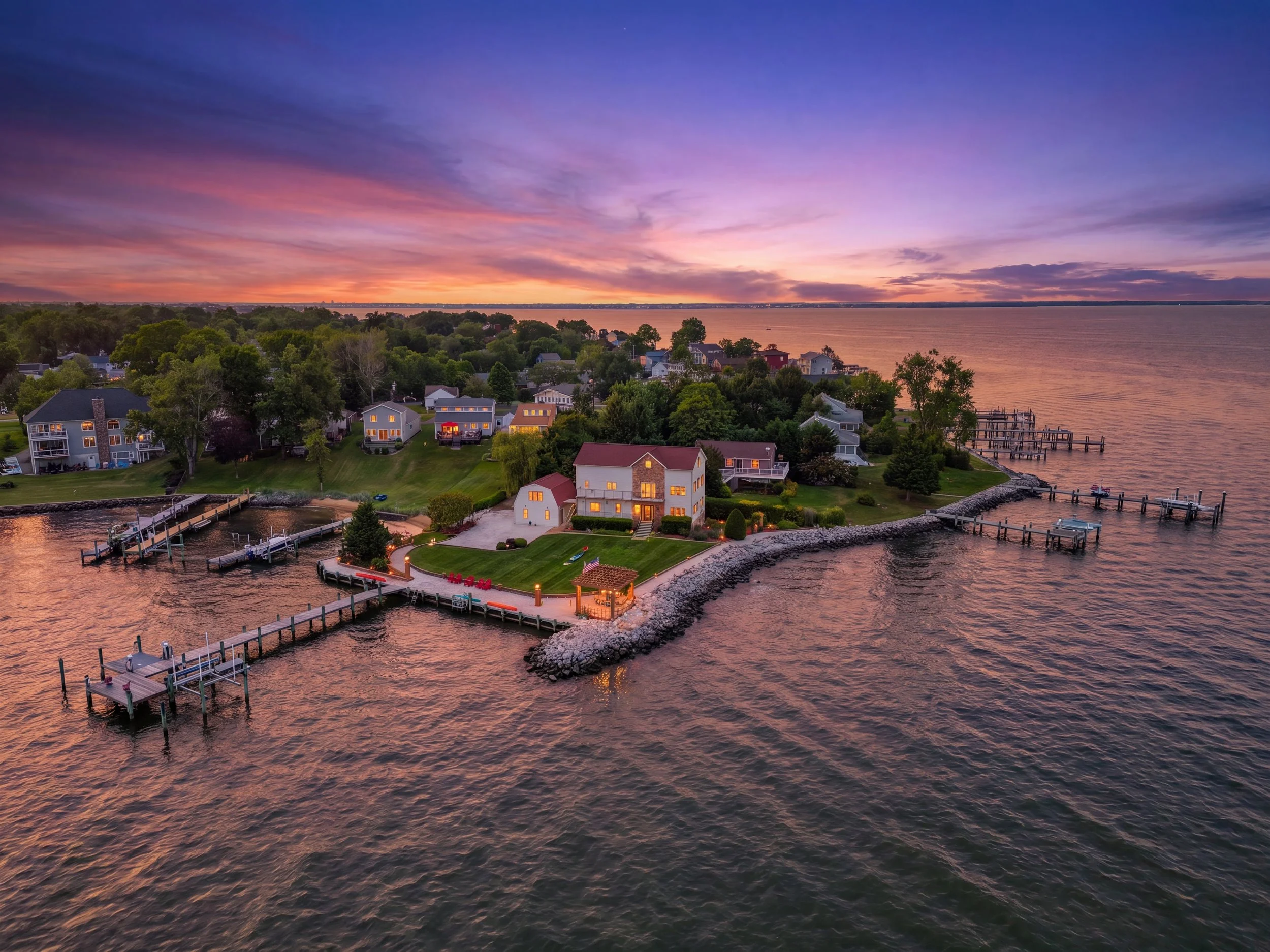
The aerial home-to-water shot. One frame showing the house, the yard, and the water frontage together — the image that answers “how close is it to the water?” in a half-second.
The dock, pier, or bulkhead. If there's a dock, slip, or boat lift, photograph it well; for many buyers it's the deciding feature of the whole property.
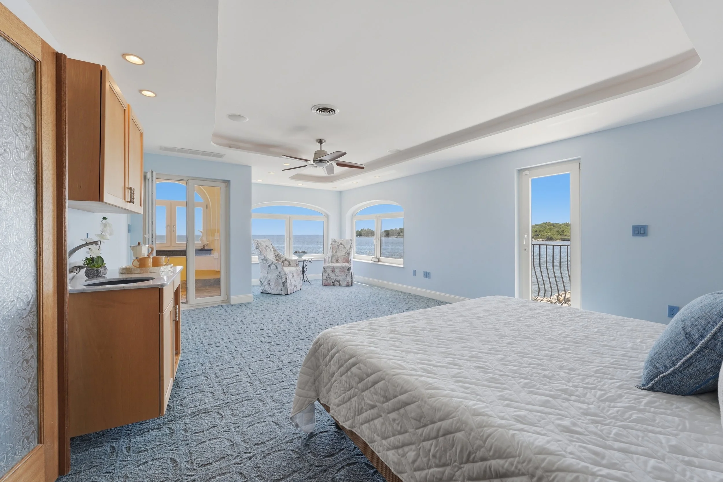
The water view from inside. Shot from the living space or primary bedroom looking out, so buyers see exactly what they'd wake up to.
The rear elevation from the water side. The view a neighbor sees from a passing boat — often the home's single best angle, and one most listings skip.
The shoreline and approach. Beach, riprap, or natural edge, plus the path from house to water, so buyers understand how the lot meets the waterline.
Beautiful, clear-sunny day out on the water in Pasadena, MD
Aerial Is the Difference-Maker on the Water
For waterfront, aerial photography isn't a luxury add-on — it is frequently the most important image in the entire set. Only an elevated angle can show the frontage, the dock's reach into the water, and the property's position relative to the cove, river, or open bay. It's also a proven performer: aerial imagery is widely cited in NAR and MLS figures as helping homes sell up to 68 percent faster than listings without it.
At Cove Media, we shoot waterfront aerials with a licensed FAA Part 107 drone pilot wherever the airspace allows — and around the Chesapeake, it usually does. But the DC region has some of the most tightly regulated airspace in the country, so where a listing sits determines what's possible.

Airspace map of the DC region. Everything in red is restricted (no-fly); the blue rings require LAANC, which is typically auto-approved.
Where You Can Fly Around the Chesapeake
The DC area is layered with flight restrictions radiating out from Reagan National Airport (DCA):
The Flight Restricted Zone (FRZ) is the inner no-fly core covering DC and the close-in suburbs (Alexandria, Arlington, Bethesda, inner Prince George's). Drone flight is effectively prohibited here.
The Special Flight Rules Area (SFRA) is the wider ring where Part 107 flights are permitted with the proper authorization.
Airport airspace around fields like BWI and Annapolis's Lee Airport (ANP) is controlled and requires LAANC authorization before takeoff.
The good news for Chesapeake listings: Pasadena and most of Anne Arundel County sit outside the FRZ, so real aerial photography is on the table for the large majority of waterfront homes here. Annapolis is mostly flyable too, though pockets near Lee Airport fall into controlled airspace that needs authorization first. For the close-in Northern Virginia and DC addresses that are inside the FRZ, we capture an elevated “simulated aerial” using a 360 camera on a 20-foot boom pole instead — not identical to a true drone shot, but a legal way to get above eye level where flying isn't allowed. For the full breakdown of rules and pricing, see our guide to real estate drone photography in the DC metro.
Timing, Light, and Glare on the Water
Water adds two wrinkles to lighting: bright reflections and a constantly moving surface. Our HDR bracketing approach handles the reflection problem well — by blending several exposures, we keep both the bright water and the shaded interior properly exposed, with no blown-out windows. Overcast days are genuinely fine and often flattering for waterfront, so a grey forecast is no reason to reschedule. For east-facing homes, a morning shoot puts soft light on the water; we wrap shoots by mid-afternoon, and when a dramatic dusk look is wanted, virtual twilight editing delivers it without a separate evening visit.
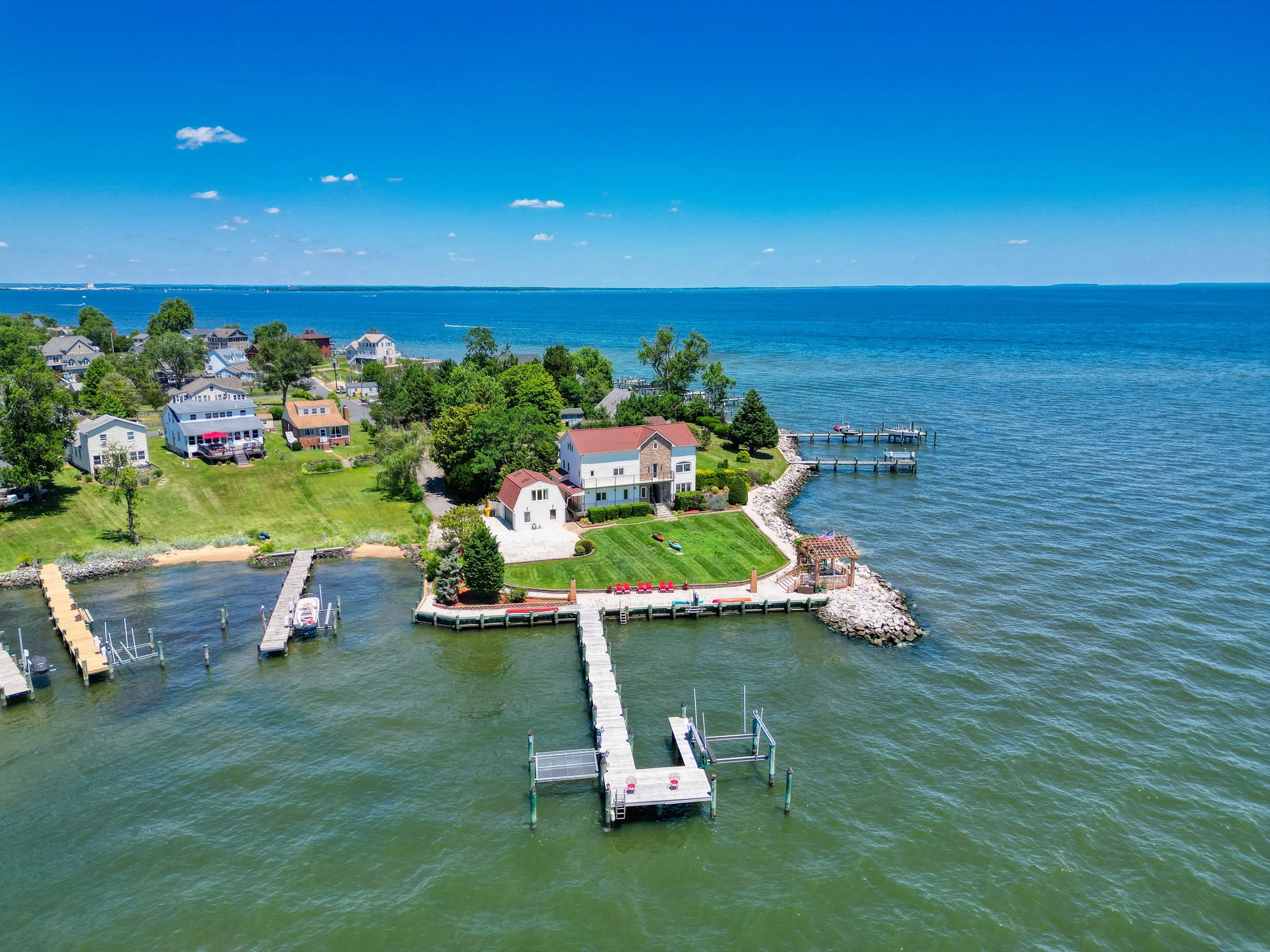
Stunning clear views of the Chesapeake Bay.
Waterfront Markets We Cover
The Chesapeake and its rivers give this region an enormous amount of water frontage, and we photograph listings across it. In Anne Arundel County that includes Pasadena, Annapolis, Severna Park, Arnold, Edgewater, Riva, Mayo, Galesville, Shady Side, Deale, and Gibson Island. We also cover waterfront communities in Queen Anne's County — Kent Island, Stevensville, and Grasonville — along with Chesapeake Beach, North Beach, and Solomons in Calvert County, and the Middle River and Essex areas of Baltimore County. On the Virginia side, we shoot Potomac-front listings in Alexandria, Mount Vernon, Occoquan, and Woodbridge, using the boom-pole method where FRZ rules apply.
Preparing a Waterfront Listing for the Shoot
A little waterfront-specific prep makes a big difference. Clear and tidy the dock — coil hoses, stow bumpers and lines, and remove anything stored on the pier. If there's a boat lift, decide whether you want the boat in or out of frame. Rake the shoreline and clean the bulkhead or riprap where you can, and tuck away kayaks, paddleboards, and lawn gear unless they're staged intentionally. Calm water photographs best, so a still morning is ideal when the schedule allows.
Waterfront homes are some of the most rewarding listings to photograph — and some of the easiest to under-market. Shot well, with the right aerial, the right water views, and clean prep, they don't just look good online; they sell the lifestyle that makes them worth the premium.